Optimize
GravitasEDGE applications have been designed with the latest technology to create a seamless and optimal workflow for Operational Geoscience. Iconic applications such as Winlog have been completely re-engineered to take advantage of the power of the web to deliver a full well lifecycle workflow for all well projects including hydrocarbon extraction, gas storage, radioactive/nuclear waste disposal and storage, CCS/CCUS and geothermal. Integrated solutions are available for real-time log visualization and analysis, well correlation, pore pressure monitoring and daily and end of well reporting.
All applications are supported by the cloud ready GravitasEDGE Platform enabling real-time, multi-user, multi-well access to well data, logs, reports and documents for all connected GravitasEDGE users. Enterprise users can utilize the DataBridge to connect users on rigs, offices and homes throughout the world to create a globally distributed interpretation platform, even when working with intermittent communication links.
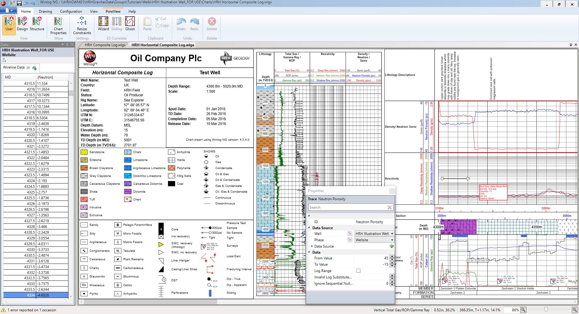
Winlog is the most flexible log drawing and interpretation application available today. Winlog is an unrivalled solution for visualizing wells and managing operational geology workflows and data-flows
- The embedded Well browser links log traces with underlying data
- Search for wells using tags
- Intuitive data import workflow
Readily customize log formats to support operational visualization and field data collection needs
- Full well lifecycle support through planning, drilling, QA/analysis and abandonment phases
- Easily compare planned vs. actual vs. offset datasets on a single log
- Data entered once is available for use on multiple logs
- Create logs with multiple depth sections at different scales; for example to emphasize zones of interest
- Plot along any axis

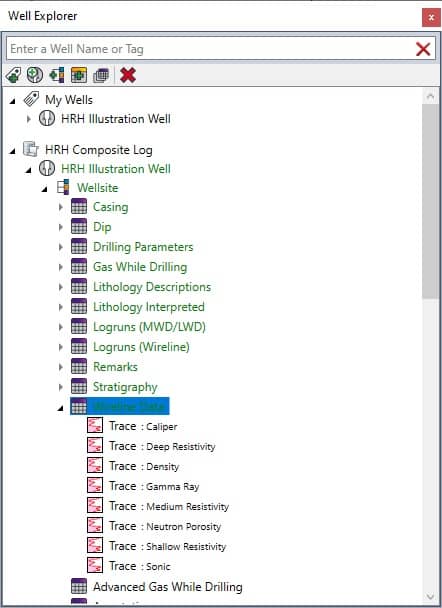
Embedded Well Explorer
All GravitasEdge Apps benefit from the embedded Well Explorer
- Simplified well navigation
- Inbuilt Well Explorer
- Fully integrated into Winlog UI
- Intuitive data interaction
- Winlog objects and underlying data visually linked
- Quick calculations (min, max and mean)
- Filtering
- Searching

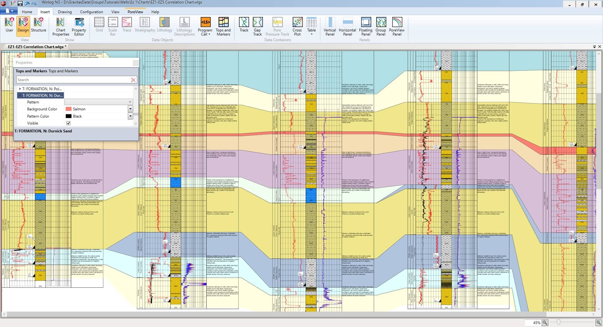
Create quick, simple and informative correlation charts to help navigate your well. Designed specifically for operational correlation, the EZ-Correlate App allows the user to:
- Visually compare drilling and offset wells
- Co-visualize logs from the same well e.g. engineering and geological logs
Interpretative workflows are enabled through EZ-Correlate’s dynamic charts. Inbuilt functionality allows the user to:
- Drag curves to compare peaks with ghosting
- Align the well based on a formation top or marker with flattening
- Manually align features of interest with sliding
Correlate against existing GravitasEDGE wells or digitized legacy wells. EZ-Correlate has been optimized to handle large bitmap formats.
POREVIEW extends the capability of Winlog to easily and intuitively calculate pressure profiles within the GravitasEDGE platform.
- Enables geologists and pressure engineers to analyze and calculate pore pressure and fracture gradients in real-time
- Calibrate predictions, mitigate drilling risks and significantly reduce response time during drilling
- The unique calculation engine extends the capability of all PPFG models to correctly evaluate and manage pressure evaluation when planning and drilling high-angle wells
- CalcStacks™ and CalcBlocks provide an agile, intuitive means of building composite PPFG curves
- Easily integrate pressure calculations onto wellsite logs
- Effortlessly generate end of well PPFG reports with the Reporter App
- PoreScript™ enables custom PPFG models to be created
- Calculations run concurrently and automatically
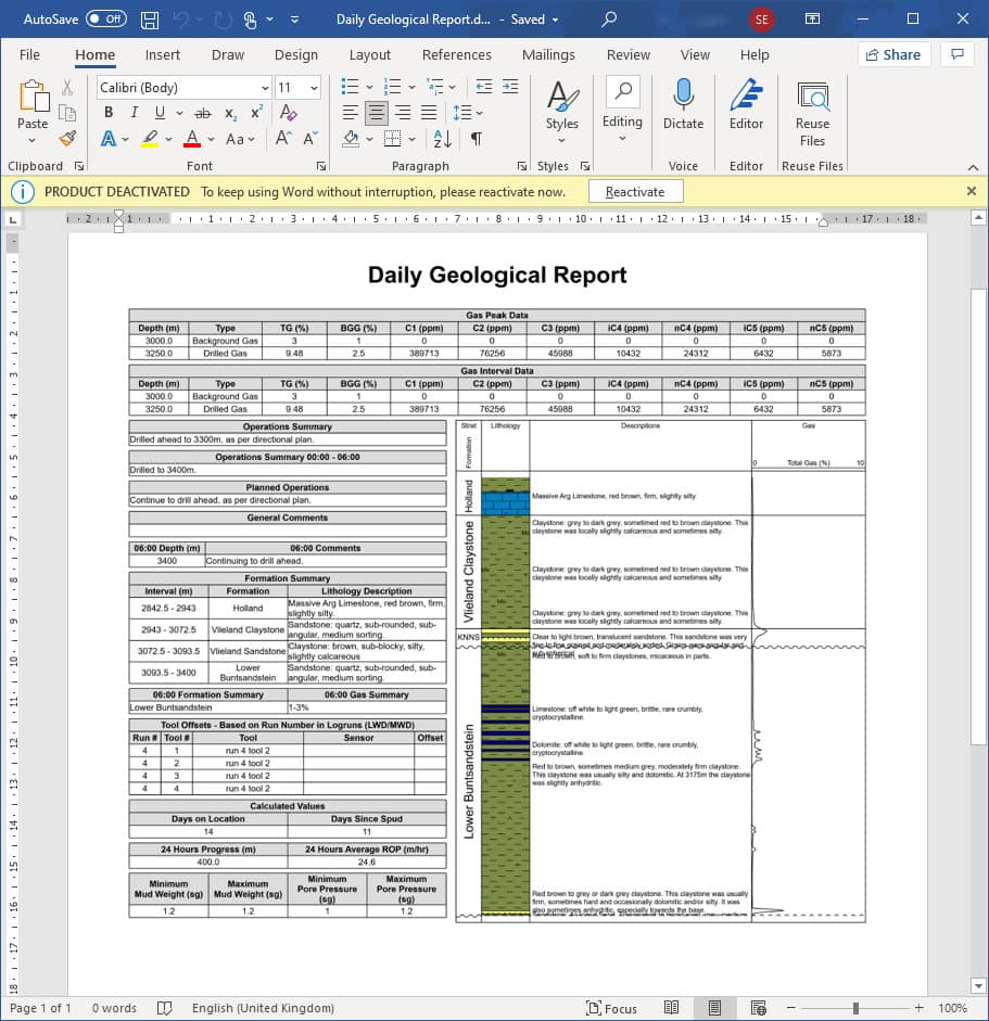
The Reporter App for GravitasEDGE generates accurate, consistent and high quality reports directly into Microsoft® Word™
- Fully integrated with MS Word
- Utilize Word templates to create a consistent look and feel
- Incorporate charts and plots direct from Winlog
- Graphics are automatically generated
- Supports the full well lifecycle in GravitasEDGE
- Planning / pre-drill Reports
- Daily Geological Reports
- Planned vs Actual Reports
- End of Well Reports
- Well Summary Reports
- Multi-lateral well Reporting
- Fully customizable to any bespoke report design
- Fully integrated within the GravitasEDGE Platform and Mobile App for private cloud storage, synchronization, distribution and viewing of reports
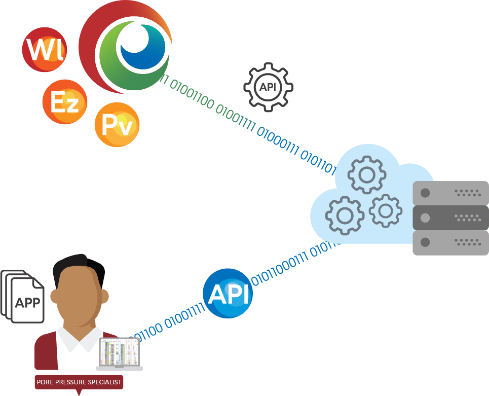
The industry’s first open API for operational geoscience integrates your workflows with your geologist in the cloud. Seamlessly integrate with other disciplines such as drilling and asset geoscience.
Powerful API:
- Author your own applications
- Integrate work flows and data flows with drilling and subsurface
- Build your own Blue Book data flow
- Table read/write
- Channel read/write for real-time
- Interpret and visualize your data how you choose
Trusted Industry Standard Technology
- OData
- Discoverable Schema with Supporting Cookbook
- Stateless HTTP consumable by almost any programming language
Secure
- Trusted Authentication and Identification Technology
- OAuth2
The GravitasEDGE Discovery Zone is the on demand, online training portal for the GravitasEDGE software. The portal provides access to modular training exercises designed to ensure user proficiency and the smooth onboarding of new users.
Subscribed users will navigate through recorded demonstrations and real workflow exercises covering the full suite of GravitasEDGE applications: Winlog, EZ-Correlate, PoreView and Reporter.
Within hours, new users will have the expertize to:
- Create new wells and enter all required data
- Create required charts (e.g. wellsite logs, composite logs, well correlation panels etc)
- Synchronize data between the wellsite and office
- Create and share charts and reports
- Edits well and chart templates to display data in the desired format
The GravitasEDGE Discovery Zone also provides training around the advanced features in GravitasEDGE. Administration, chart design, Logscript and PoreScript, enable users to design and implement fully customized data visualization and analytical workflows across any number of wells.
Customize
Combining the power of the GravitasEDGE platform and proprietary Apps with highly trained and experienced personnel enables the delivery of unparelled services. Continued investment and innovation allows HRH Geology to meet the challenges and opportunities facing the Energy industry both now and in the future.
Customized services delivered with our people and GravitasEDGE improve performance and outcomes. Whether that’s improving operational efficiency, integrating data, combining solutions, improving decision making or developing solutions for the energy transition, customized services add significant value to clients.
Geological Services and Support
- Wellsite geology service at the rig site
- Full wellsite geology service is tailored to suit client requirements, powered by GravitasEDGE
- Remote drilling service delivered through the GravitasEDGE Data Bridge
- Bespoke wellsite drilling service, deployed via GravitasEDGE that delivers geological requirements remotely, inline with client requirements
- Operations geology
- Provision of operations geology services across the lifecycle of a well project. Collaborate across disciplines and integrate through GravitasEDGE
- Carbon capture and storage
- Geological analysis and interpretation services, alongside traditional wellsite geology, to support the delivery of carbon capture and storage projects
- Geothermal Energy
- Wellsite geology services tailored for the Geothermal industry, using GravitasEDGE to create a real-time dataset whilst drilling
Training and Mentoring Services
- Geological and drilling training services
- Full range of accredited training, from entry level to advanced/specialist level courses. Syllabus covers geology and related disciplines
- Online instructor-led training courses delivered using the latest technology
- Wellsite geology operations development and training
- Customized development plans for those working in wellsite operations geology. Designed to enhance skillsets and knowledge through training, coaching and mentoring.
- Customized training and development
- A client-specific, fully customizable programme of training and development
- Software training and support services
- The GravitasEDGE Discovery Zone training portal provides a flexible training solution for our GravitasEDGE software
Consultancy Services
- Software Consultancy
- Comprehensive range of customization and support services to maximize the value of GravitasEDGE for clients' field data collection, log visualization, reporting and interpretation needs
- Process improvement services
- Advanced services to review and update workflows to optimize companies' well delivery processes
- Plug and abandonment services
- As part of a multi-disciplinary team, using GravitasEDGE to visualize, analyze and interpret geological data throughout the full P&A cycle
- Carbon Capture and Storage
- Suitability assessment of reservoirs/locations based on geological data and profiling.
- Development of programme plans and specialist studies to support CCUS/CCS projects
- GravitasEDGE Open API Custom Apps
- Development of bespoke GravitasEDGE applications and custom integration with other applications

Delivering the rig of the future
“The advent of widespread digitalization and the cloud has created a unique opportunity to build a new generation of Operations Geology software for the rig of the future, improving collaboration and productivity for our customers. Engineered with the latest technology, users have access to a rich operations geology toolset to manage the geological workflow and seamlessly integrate with other disciplines such as drilling and asset geoscience.”

